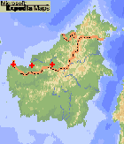
 Range of Nageia maximus (1). Adapted from a map by www.expediamaps.com | Nageia maximus (de Laubenfels) de Laubenfels 1987Common NamesLandin paya [Naman Forest Res.] (1).Taxonomic notesSyn: Decussocarpus maximus de Laubenfels; Podocarpus maximus (de Laubenfels) Gaussen (1).Description"Erect shrub to tree, 1-10 m high. Leaves (8-) 16-34 by (3-) 6-9.5 cm, acuminate, 2.5-3.5 times as long as broad; petiole 4-10 mm. Pollen cones in groups of up to 9 on a 3-10 mm peduncle, 12-20 by 2.5-3 mm. Apex of microsporophyll more or less lanceolate, 0.5-1 mm long. Seed-bearing structure solitary or grouped to as many as five on a scaly shoot c. 6 mm long, the individual peduncles up to 12 mm long, not forming a fleshy receptacle. Seed and its cover 16-188 mm diam." (1).RangeBorneo: Sarawak, very local. Locally common in the understory of rainforest on ridge in Bako National Park and in the peat-swamp forest, from ca. 0-120 m (1).Big TreeOldestDendrochronologyEthnobotanyObservationsRemarksCitations(1) Laubenfels 1988. |
[Nageia] [Podocarpaceae] [home] This page is from the Gymnosperm Database |